Technische Universität Wien
Orientation and Processing of Airborne Laser Scanning data
Department of Geodesy and Geoinformation - Research Groups Photogrammetry and Remote Sensing
Provides a raster map of local viewsheds (i.e. openness) based on a DTM grid model.
Openness is a measure introduced by Yokoyama (c.f. references). It is an angular measure denoting the aperture angle of a cone centered at a grid point and constrained by the neighboring elevations within a specified radial distance. It is basically a convexity/concavity measure calculated from local terrain profiles in eight directions of the wind. A distinction is made between positive and negative openness (viewshed above and below the terrain).
This example shows how to derive an openness map based on the surface model of demo data set strip21.laz located in the $OPALS_ROOT/demo/ directory. To generate the DSM, please perform the following preprocessing steps:
To calculate the positive openness map, type:
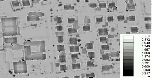
Since no further parameters are specified, the default kernel size (5 pixel radius) is considered and each openness pixel is calculated as the mean value of all 8 profile directions resulting in the GTiff file strip21_pos_open_mean.tif.
To calculate a negative openness map using a kernel radius of 7 pixels for each pixel and using the profile with the minimum opening angle, type:
To visualize the resulting map as a grey-tone image, execute:
The following output is produced:
Yokoyama, R., M. Shirasawa, and R. J. Pike: Visualizing Topography by Openness: A New Application of Image Processing to Digital Elevation Models, Photogrammetric Engineering and Remote Sensing(68), No. 3, March 2002, pp. 25799866.
G. Mandlburger, M. Vetter, M. Milenkovic, N. Pfeifer: "Derivation of a countrywide river network based on Airborne Laser Scanning DEMs - results of a pilot study"; 19th International Congress on Modelling and Simulation. Perth, Australia; 2011 in: "Modelling and Simulation Society of Australia and New Zealand", (2011), ISBN: 978-0-987214399-7; 2423 - 2429.
 1.8.17