Technische Universität Wien
Orientation and Processing of Airborne Laser Scanning data
Department of Geodesy and Geoinformation - Research Groups Photogrammetry and Remote Sensing
Analyses a regular or hybrid grid model and generates an approximating TIN surface based on a coarse-to-fine approach.
Due to the high amount of data provided by ALS sensors, the simplification of surface grids (DTM, DSM...) derived from dense ALS point clouds is an important issue, above all for data delivery. To condense the data contained in high resolution ALS grids, it is necessary to analyze the surface and preserve all relevant surface features while, at the same time, generalize the surface as much as possible. Module Simplify uses a mesh refinement approach to iteratively refine an initial coarse grid.
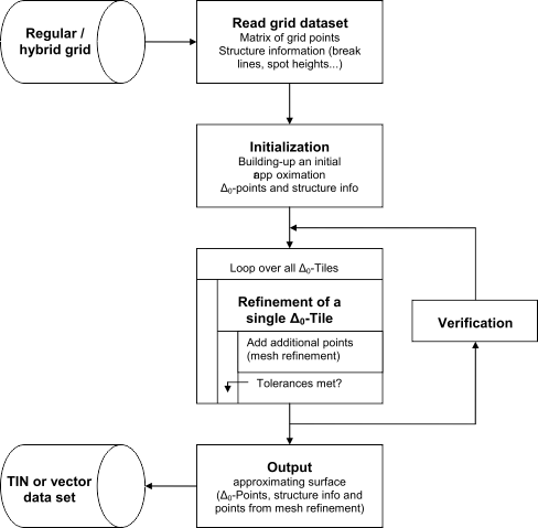
The basic parameters for the data reduction are the input grid (parameter infile), a maximum height tolerance \(\Delta z_{max}\) (parameter maxTol) and a maximum planimetric point distance \(\Delta xy_{max}\) (parameter maxDist). The algorithm starts with an initial approximation of the input grid comprising a coarse regular grid (cell size=dxymax= \(\Delta_0\)) and all line information, which are triangulated using a constrained Delaunay triangulation. Each \(\Delta_0\)-cell is subsequently refined by iteratively inserting additional grid points until the height tolerance \(\Delta z_{max}\) is met. The general processing sequence is illustrated in Figure 1:
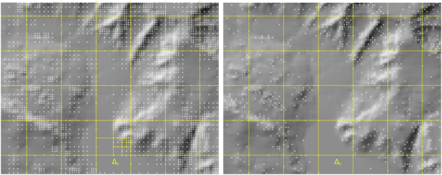
Within the refinement loop, additional vertices can either be inserted hierarchically or irregularly (parameter division). In case of hierarchical division, the grid cell is divided into four parts in each pass, if a single grid point within the regarded area exceeds the maximum tolerance \(\Delta z_{max}\) resulting in a quadtree-like data structure. By contrast only the grid point with the maximum deviation is inserted when using irregular division. Higher compression rates (up to 99% in flat areas) can be achieved with irregular point insertion, whereas the hierarchical mode is characterized by a more homogeneous data distribution. Figure 2 shows the different point distribution based on hierarchical and irregular division.
As a prerequisite for the subsequent examples, generate a digital surface model of the dataset strip21.laz (located in $OPALS_ROOT/demo/) by executing the following commands:
To obtain a simplified surface model with a maximum height tolerance of 25cm compared to the original DEM, type:
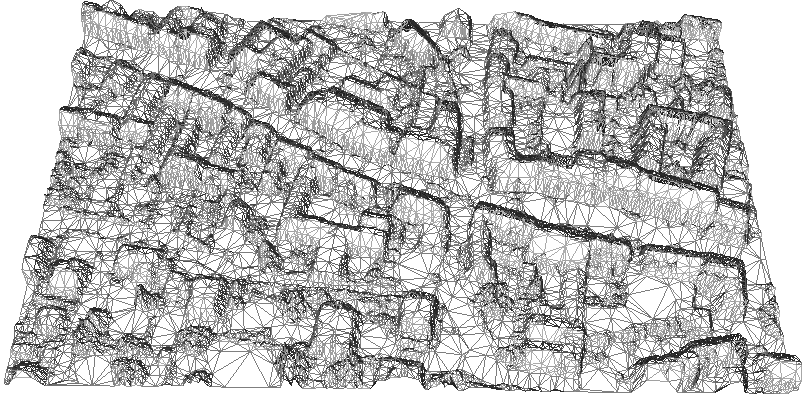
A perspective view of the resulting TIN is shown in Figure 3.
Mandlburger, G., Hauer, C., Höfle, B., Habersack, H. & Pfeifer, N., 2009: Optimisation of lidar derived terrain models for river flow modelling. Hydrology and Earth System Sciences, 13 (2009), S. 1453 - 1466.
Mandlburger, G. (2006). Topographische Modelle für Anwendungen in Hydraulik und Hydrologie. Ph. D. thesis, Vienna University of Technology
 1.8.17