Technische Universität Wien
Orientation and Processing of Airborne Laser Scanning data
Department of Geodesy and Geoinformation - Research Groups Photogrammetry and Remote Sensing
Loads vector and raster data into an ODM for subsequent use in modules dealing with point cloud and line related data.
Module Import tries to preserve the full information of imported file formats. Therefore, the ODM contains an additional administration level, storing header and layer information for each file. Hence, it is possible to reproduce the original files from an ODM file (even in case of a multiple file import). Currently, Module Import supports 6 different vector file formats. Additionally, any of the supported raster formats may be imported. However, please notice that this is a rather rare use case: raster data imported into an ODM will be treated like any other data in an ODM i.e. the topological information defined implicitly by rasters is lost.
OPALS uses the OPALS Data Manager (ODM) for the administration of ALS point clouds as well as line related geometries (eg. breaklines, formlines, borderlines). All subsequent OPALS modules dealing with primary topographic data are based on a data manager file (*.odm) as data input. Thus, running Module Import is a pre-requisite step for many OPALS application modules like Module Grid, Module Cell, Module Bounds ...
The ODM can be seen as a database system with focus on spatial data administration. Since the data are organized in a spatial order, the ODM provides efficient spatial access. The second key feature of the ODM is the storage of an arbitrary number of attributes (in OPALS they are referred to as additional info) for each geometry entry. Moreover, additional infos (addInfo) can be dynamically added at any time, allowing OPALS modules a transparent propagation of computational results across module boundaries (eg. Module Normals which estimates surface normals in each point).
For more details on the ODM and its features please refer to OPALS Data Manager manual.
In general it is not necessary to specify the file format of the input file since OPALS automatically detects the format based on the file content (and NOT based on the extension). In case the recognition fails and for formats described by a generic opals format definition, the file format can be specified by the iFormat parameter. opalsImport supports the listed format labels as shown below. For GDAL file formats it is either possible to use the generic format label gdal or the specific GDAL driver name as listed here .
| Format | Description |
|---|---|
| wnp, bwnp | Winput and binary Winput files |
| xyz, bxyz | xyz and binary xyz files |
| las | LAS files |
| shape | ESRI shape file format |
| sdw | Riegl SDW files |
| fwf | IPF internal full waveform text format (version: 0.8, 0.9, 1.0, and 1.1) |
| <opals format definition xml file> | Generic import of text and binary file |
| trj, btrj | Text and binary trajectory files. For details see Trajectory file |
| scop | SCOP DTM file format (Random Digital Height, RDH) |
| gdal | GDAL readable file format (see Supported grid/raster formats) |
| <GDAL driver name> | Use a specific GDAL driver to read the file. Driver names are listed in Supported grid/raster formats |
To import multiple files one can set all input files at once or make multiple Module Import runs in appending mode. To append data to an ODM file define the corresponding ODM file as first input file or define the ODM file as input and output file.
For some LiDAR processing steps it is necessary to know the beam vector for each point. Therefore opalsImport provides the possibility to consider trajectory files during import. It is possible to specify a single trajectory file that is used for all input files or multiple trajectory files where each trajectory file corresponds to an input file. In case the gps time range of the trajectory file doesn't fully cover the gps time range of the corresponding input file an exceptions will be thrown. For situations where the trajectory is given in multiple files which do not match the time range of input files, it is necessary to concatenate all trajectory data into a single trajectory file. Beside the beam vector in the world coordinate system (default option) it is possible to append the range, the scan angle and the beam vector in the sensor coordinate system (SCS) (see parameter storeBeamInfo). The latter two options require the computation of the beam vector in the sensor coordinate system which is the inverse operation of opalsDirectGeoref (a mounting calibration is not supported yet). Please note that the correct transformation can only be applied if the world coordinate system (see global parameter coord_ref_sys) is specified correctly (For details refer to the section World coordinate system). The beam vector in SCS can be used e.g. to improve the mounting calibration for data sets where only the final word coordinate point data and the trajectory is available by creating artificial strip files in the sensor coordinate system.
The link between point data and trajectory is given by the gps time, which limits this import parameter to file formats containing gps time information. The flight position at shot time is interpolated in a piecewise linear manner within the trajectory data. OPALS supports different trajectory file formats including the generic import. The format has to provide the data columns x, y, z, gps time, roll, pitch and yaw. Please refer to section trajectory file for further details.
The ODM tiles point data for efficient handling of huge data sets. Since tiles are always completely loaded into the memory, appropriate tile size estimation is important. This is why a spatial index statistics is reported after import. Too big tiles can lead to memory problems, too small tiles increase the administration overhead. The point density of LiDAR data is usually quite homogeneous making the tile size estimation non-crucial. However, in rare situations it can be necessary to influence the estimation process by setting the tileSize or the tilePointCount parameter. Please refer to section Analysing the index statistics of an ODM for further details.
Finally, it should be mentioned that it is possible to filter data during import in a very flexible way. This can be relevant if only a subset of the data should be passed to a processing chain. For details on filters and how they are defined please refer to the Filter manual.
All data used in the following examples are located in the $OPALS_ROOT/demo/ directory of the OPALS distribution. To import the LAS file strip31.laz into the ODM, simply type:
Since no output file is specified, the name of the corresponding ODM file is estimated from the input file name and the file ...
... constituting the ODM is created.
To add more than one strip to a single ODM file, multiple input files can be specified in a single command:
Please note that quotes are only necessary if the file names contain blanks, which is not the case in this example. For convenience multiple files can be specified using wildcard characters (*,?) as well:
The same result could have been achieved by calling Module Import multiple times and by appending the data to a single ODM.
In case, the automatic recognition of the input files' data format fails, it is nonetheless possible to import the files, if the proper input data format is specified. If multiple input files are used, then the number of files must match the number of input formats. This also applies for appending additional data files to an existing ODM. Thus, the very same example as above can be written as:
Data in generic text (or binary) format can be imported by providing a OPALS Generic Format file in XML format. The file fullwave.fwf, for instance, contains eight columns (x, y, z, time, amplitude, echo width, echo number, echo qualifier) per line (=data set).
With the following format definition file ...
... stored as myFormatDef.xml, the file can be imported as follows:
In fact, the file satisfies the I.P.F. full waveform format specification, and thus there is no need for a user defined format definition file in this place. But instead, sometimes it is desired to read only specific parts of a data file. Filters can be used to read, e.g. only the first echoes or echoes with amplitudes above a certain threshold.
Please mind that quoting the filter string is necessary in the latter case due to the embedded blanks and special characters. It is recommended always to quote complex filter strings. For more detailed information about selective data import please refer to the Filter manual.
For some processing tasks, such as radiometric calibration and rigorous strip adjustment, beam information is required. Whereas the beam information is directly given for data in sensors coordinate system, sometimes only the final coordinates in the world coordinate reference system are available. In such situation the inverse operation to Module DirectGeoref is required. So in case the trajectory file exists and the input data file contain the corresponding GPS time stamps, Module Import can compute different beam informations and attach the values as attributes to the imported points.
In the following we re-compute sensors coordinates from a LAS file (world coordinate reference system) that was processed by Module DirectGeoref as shown in DirectGeoref Example 1. In case 060622_173547_dirGeoref.las doesn't exist yet, run the following commands in the $OPALS_ROOT/demo/ directory:
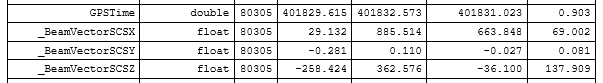
Now, process the following command which imports the LAS file (world coordinate reference system) and appends the sensors coordinates of each points as attributes (_BeamVectorSCSX, _BeamVectorSCSY, _BeamVectorSCSZ)
Using Module Info the attributes and their range of the newly created ODM can be checked
By converting the original SDC file into a simple xyz text file the range of the sensors coordinates will be output at end
allowing for a simple comparison
Otepka, J., Briese, C. and Nothegger, C., 2006. First steps to a topographic information system of the next generation. In: Symposium of ISPRS Commission IV - Geo Spatial Databases for Sustainable Development, Goa, India.
Mandlburger, G., Otepka, J., Karel, W., Wagner. W. and Pfeifer, N., 2009. Orientation and Processing of Airborne Laser Scanning data (OPALS) - concept and first results of a comprehensive ALS software. ISPRS Workshop Laserscanning 2009, Paris, France.
 1.8.17